Tropical Storm Erin has formed in the Atlantic and, based on current atmospheric conditions, is forecast to intensify potentially becoming the first hurricane of the season. Here’s an in depth breakdown of what that means, the mechanisms behind the storm’s evolution, and what might lie ahead.
Formation and Favorable Conditions
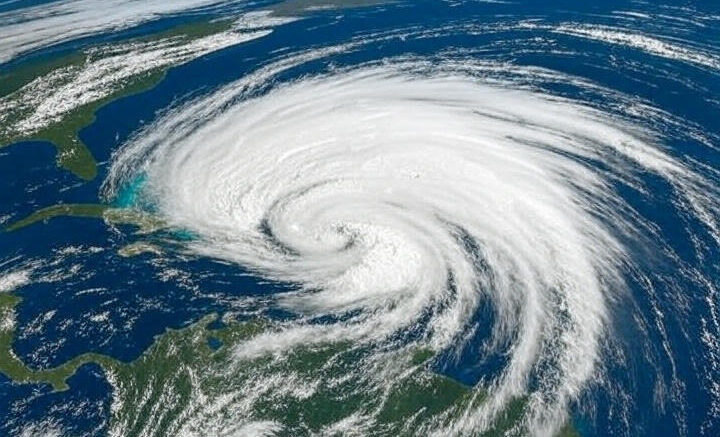
Formation in the Atlantic Basin Tropical disturbances in the western Atlantic occasionally consolidate into tropical storms when they encounter sufficiently warm sea surface temperatures (typically above 26 °C or about 79 °F), low vertical wind shear, and moist mid level air. Erin has apparently found exactly those conditions, enabling its classification as a tropical storm.(CNN).
Why Erin Could Become a Hurricane Several key ingredients appear favorable:
Warm Ocean Waters: The Atlantic specially in early August is usually warm enough to fuel rapid intensification.
Low Wind Shear: Minimal difference in wind speed and direction from the ocean surface to the upper atmosphere helps storm structure stay intact and organized.
Moist Environment: Dry air intrusion can suppress storms, but Erin seems to be in a moister environment, reducing such interference.
First Hurricane Potential If Erin strengthens to sustained winds of at least 74 mph (119 km/h), it will be designated a Category 1 hurricane. Considering the storm’s timing, this would mark the first hurricane of the Atlantic season a milestone that’s both meteorologically and publicly notable.(Globedge).
The Forecast and Why It Matters
Watching the Trajectory
Forecast Tracks: Meteorological agencies such as the National Hurricane Center typically provide “cone” graphics showing the probable path. These models help estimate coastal areas at greatest risk.
Landfall Possibility: Intensification into a hurricane increases concerns about storm surge, coastal flooding, and wind damage. Regions along the projected path whether Caribbean islands, the U.S. eastern seaboard, or other coastal zones should monitor updates closely.
Rapid Intensification Concerns Sometimes, storms intensify quickly so called rapid intensification going from a tropical storm to major hurricane status in short order. If Erin encounters particularly warm waters and extremely favorable dynamics, such a scenario, while not guaranteed, could pose heightened risks with less preparation time.
Broader Climate Context
Trend toward Early Hurricanes In recent years, some hurricane seasons have started earlier or produced their first hurricane sooner than historical averages. While a single storm doesn’t confirm a trend, scientists keep an eye on seasonal patterns, ocean temperatures, and climate signals (like El Niño or La Niña) that modulate hurricane activity.
Public Awareness and Preparedness The designation of “first hurricane of the season” often serves as a wake-up call. Even if landfall isn’t imminent, emergency agencies may review preparedness plans, ensure public communication channels are ready, and remind residents of evacuation routes and safety protocols.
What to Expect Going Forward
Regular Updates Watch for advisories from official sources such as the National Hurricane Center, regional meteorological services, or national weather agencies. These typically include details on:
Wind speeds and central pressure
Current movement and forward speed
Forecast tracks and intensity projections
Watches or warnings issued for specific coastal areas
Stay Informed and Prepared
If you’re in a potentially affected zone, review your hurricane kit (water, non perishables, medicine, radios).
Know evacuation routes and have a plan for sheltering or relocating if warnings are issued.
Monitor updates through reliable media especially if Erin intensifies or deviates from predicted paths.
Summary
Erin has formed as a Tropical Storm in the Atlantic and is forecast under favorable conditions of warm water, moist air, and low shear o potentially strengthen into the first hurricane of the season.
This upgrade would be significant: signaling elevated risks, possibly rapid intensification, and prompting enhanced public and governmental awareness.
The trajectory and timing will determine the real-world impact particularly regarding potential landfall, storm surge, and wind damage.
Stay tuned to official meteorological advisories and prepare accordingly regardless of whether Erin becomes a hurricane, tropical storms themselves can still be dangerous.